GHANA GEOSPATIAL SOCIETY

Contact us

Geospatial Scientific and Technology Working Group

Facilitating the operations, growth and promoting the civic responsibility of the Institution, taking cognizance of the different disciplines but subject to new additions, merger or any other decisions to make it effective.

Scientific & Technical Working Groups

GWG - 1 Geo-Social Sciences

GWG - 1 Geo-Social Sciences (Media, Communication, Ethics and Governance etc

GWG - 2 Geo - Health and Science

GWG - 2 Geo- Health and Science

GWG - 3 Geo-Environment & Natural Resources

GWG - 3 Geo-Environment & Natural Resources (Climate change & Disaster Management, Agric, Biodiversity, Natural Resources, Energy, etc)
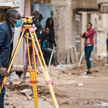
GWG - 4 Geo-Surveying & Built Environment

GWG - 4 Geo-Surveying & Built Environment (Land Management, Estates & Built Environment)

GWG - 5 Geospatial Utilities and Engineering

GWG - 5 Geospatial Utilities and Engineering

GWG - 6 Geospatial Security

GWG - 6 Geospatial Security (Military, Policing & Intelligence Services, etc)

GWG - 7 Geospatial Information Technology

GWG - 7 Geospatial Information Technology (Application Development, management, Business Intelligence, Artificial Intelligence/ robotics, Machine Learning, etc)
You may want to know something

About Us

Core Values

OUR VISION

To see to the advancement, practice, utilization and dissemination of all aspects of geospatial science and application in Ghana.

MISSION 

To be the voice and represent the geospatial community in Ghana to promote and protect the interests of its members on all forums and institutions. 


Our Code Ethics

It is important for a profession to have a Code of Ethics. “It's not that we expect the Code will be a front-line of defense against wrong-doing. Instead, the Code provides a touchstone for members to identify and resolve ethical dilemmas that they encounter in their work.”

The Code of Ethics is intended to provide guidelines for Geospatial professionals. It should help professionals make appropriate and ethical choices. It should provide a basis for evaluating their work from an ethical point of view. By heeding this code, Geospatial professionals will help to preserve and enhance public trust in the discipline. The text of this code draws on the work of many professional societies. A few of the guidelines that are unique to the Geospatial profession include the encouragement to make data and findings widely available, to document data and products, to be actively involved in data retention and security, to show respect for copyright and other intellectual property rights, and to display concern for the sensitive data about individuals discovered through geospatial or database manipulations.

The Code consists of these four primary categories:

  1. Obligations to Society.
  2. Obligations to Employers and Funders.
  3. Obligations to Colleagues and the Profession.
  4. Obligations to Individuals in Society Individuals seeking certification must also certify that he or she has read and agrees to conduct professional activities in conformance with the professional Code of Ethics. Thus, conducting professional activities in an ethical manner is part and parcel of the Geospatial Certification Program.

Geospatial Code of Ethics.

This Code of Ethics is intended to provide guidelines for Geospatial (geographic information system) professionals. It should help professionals make appropriate and ethical choices. It should provide a basis for evaluating their work from an ethical point of view. By heeding this code, Geospatial professionals will help to preserve and enhance public trust in the discipline. This code is based on the ethical principle of always treating others with respect and never merely as means to an end: i.e., deontology. It requires us to consider the impact of our actions on other persons and to modify our actions to reflect the respect and concern we have for them. It emphasizes our obligations to other persons, to our colleagues and the profession, to our employers, and to society as a whole. Those obligations provide the organizing structure for these guidelines.

The text of this code draws on the work of many professional societies. It is not surprising that many codes of ethics have a similar structure and provide similar guidelines to their professionals, because they are based upon a similar concept of morality. A few of the guidelines that are unique to the Geospatial profession include the encouragement to make data and findings widely available, to document data and products, to be actively involved in data retention and security, to show respect for copyright and other intellectual property rights, and to display concern for the sensitive data about individuals discovered through geospatial or database manipulations. Longer statements expand on or provide examples for the Geospatial profession.

A positive tone is taken throughout the text of this code. Geospatial professionals commit themselves to ethical behavior rather than merely seeking to avoid specific acts. The problems with listing acts to be avoided are:

  1. There are usually reasonable exceptions to any avoidance rule and
  2. There is implicit approval of any act not on the list. Instead, this code provides a list of many positive actions. These explicit actions illustrate respect for others and help strengthen both an understanding of this ethos and a commitment to it. This code is not expected to provide guidelines for all situations. Ambiguities will occur and personal judgment will be required. Sometimes a Geospatial professional becomes stuck in a dilemma where two right actions are in conflict with each other or any course of action violates some aspect of this code. Help might come from talking with colleagues or reading relevant works such as those listed in the bibliography. Ultimately, a professional must reflect carefully on such situations before making the tough decision. Contemplating the values and goals of alternative ethical paradigms may be useful in reaching a decision.
  • View persons who exemplify morality as your own guide (Virtue Ethics)
  • Attempt to maximize the happiness of everyone affected (Utilitarianism)
  • Only follow maxims of conduct that everyone else could adopt (Kantianism)
  • Always treat other persons as ends, never merely as means (Deontology)

I. Obligations To Society

The Geospatial professional recognizes the impact of his or her work on society as a whole, on subgroups of society including geographic or demographic minorities, on future generations, and inclusive of social, economic, environmental, or technical fields of endeavor. Obligations to society shall be paramount when there is conflict with other obligations. Therefore, the Geospatial professional will:

  1. Do the Best Work Possible
    • Be objective, use due care, and make full use of education and skills.
    • Practice integrity and not be unduly swayed by the demands of others.
    • Provide full, clear, and accurate information.
    • Be aware of consequences, good and bad.
    • Strive to do what is right, not just what is legal.
  2. Contribute to the Community to the Extent Possible, Feasible, and Advisable.
    •  Make data and findings widely available.
    • Strive for broad citizen involvement in problem definition, data identification, analysis, and decision-making.
    • Donate services to the community. 
  3. Speak Out About Issues.
    • ​​​​​​​Call attention to emerging public issues and identify appropriate responses based on personal expertise.
    • Call attention to the unprofessional work of others. First take concerns to those persons; if satisfaction is not gained and the problems warrant, then additional people and organizations should be notified.
    • Admit when a mistake has been made and make corrections where possible. 

II. Obligations To Employers and Funders

The Geospatial professional recognizes that he or she has been hired to deliver needed products and services. The employer (or funder) expects quality work and professional conduct. Therefore the Geospatial professional will:

  1. Deliver Quality Work
    • ​​​​​​​Be qualified for the tasks accepted.
    • Keep current in the field through readings and professional development.
    • Identify risks and the potential means to reduce them.
    • Define alternative strategies to reach employer/funder goals, if possible, and the implications of each.
    • Document work so that others can use it. This includes metadata and program documentation.
  2. Have a Professional Relationship
    • ​​​​​​​Hold information confidential unless authorized to release it.
    • Avoid all conflicts of interest with clients and employers if possible, but when they are unavoidable, disclose that conflict.
    • Avoid soliciting, accepting, or offering any gratuity or inappropriate benefit connected to a potential or existing business or working relationship.​​​​​​​ 

Obligation to Employers and Funders Continuation

  • Accept work reviews as a means to improve performance.
  • Honor contracts and assigned responsibilities.
  • Accept decisions of employers and clients, unless they are illegal or unethical.
  • Help develop security, backup, retention, recovery, and disposal rules.
  • Acknowledge and accept rules about the personal use of employer resources. This includes computers, data, telecommunication equipment, and other resources.
  • Strive to resolve differences.
  1. Be Honest in Representations.
    • State professional qualifications truthfully.
    • Make honest proposals that allow the work to be completed for the resources requested.
    • Deliver an hour’s work for an hour’s pay.
    • Describe products and services fully.
    • Be forthcoming about any limitations of data, software, assumptions, models, methods, and analysis. 

III.Obligations to Colleagues and the Profession

The Geospatial professional recognizes the value of being part of a community of other professionals. Together, we support each other and add to the stature of the field. Therefore, the Geospatial professional will:

  1. Respect the Work of Others.
    • ​​​​​​​Cite the work of others whenever possible and appropriate.
    • Honor the intellectual property rights of others. This includes their rights in software and data.
    • Accept and provide fair critical comments on professional work.
    •  Recognize the limitations of one’s own knowledge and skills and recognize and use the skills of other professionals as needed. This includes both those in other disciplines and Geospatial professionals with deeper skills in critical sub-areas of the field.
    • Work respectfully and capably with others in Geospatial and other disciplines.
    • Respect existing working relationships between others, including employer/employee and contractor/client relationships.
    • Deal honestly and fairly with prospective employees, contractors, and vendors.
  2. Contribute to the Discipline to the Extent Possible.
    • ​​​​​​​Publish results so others can learn about them.
    • Volunteer time to professional educational and organizational efforts: local, national, or global.
    • Support individual colleagues in their professional development. Special attention should be given to underrepresented groups whose diverse backgrounds will add to the strength of the profession.​​​​​​​ 

IV. Obligations to Individuals in Society

The Geospatial professional recognizes the impact of his or her work on individual people and will strive to avoid harm to them. Therefore, the Geospatial professional will:

  1. Respect Privacy
    • Protect individual privacy, especially about sensitive information.
    • Be especially careful with new information discovered about an individual through Geospatial-based manipulations (such as geocoding) or the combination of two or more databases.
  2. Respect Individuals
    •  Encourage individual autonomy. For example, allow individuals to withhold consent from being added to a database, correct information about themselves in a database, and remove themselves from a database.
    • Avoid undue intrusions into the lives of individuals.
    • Be truthful when disclosing information about an individual.
    • Treat all individuals equally, without regard to race, gender, or other personal characteristics not related to the task at hand.

Our Constitution

Become A Member

Types of Membership

Honorary Fellow: Consist of Members Being Conferred fellowship to foster excellence, integrity, interdisciplinary collaboration and strategic advice to promote professional development and engagement of Geospatial scientists from all backgrounds.

Click To Create An Account And Apply

Consist of organization, institutions both private and/or public that may enter into affiliation with the society. They Could be having part or whole of their work in any geospatial related field.

Click To Create An Account And Apply

Consist of individuals who are practicing their profession any Geospatial related roles.They must have certificates or proof of their qualifications.

Click To Create An Account And Apply

Open to anyone who is currently studying in the second cycle and tertiary institution or any higher learning programs in courses relating to the field of Geospatial or involved in research in this field.

Click To Create An Account And Apply

You may want to

Contact us

  • Address: 1st Floor Okyere Plaza, Kingsby mile 7
  • (+233) 3029-04356
  • info@ggs.org.gh